Zip Codes are Not Area Polygons
....Perhaps the most common misconception in GIS is that Zip codes in the United States are polygonal regions or areas. People often think of mapping in the US as a hierarchy of ever-subdivided polygonal areas: states, counties, cities, zip codes. If they need higher resolution than a county, they next leap to zip codes because they think of zip codes as polygons. This is not true.
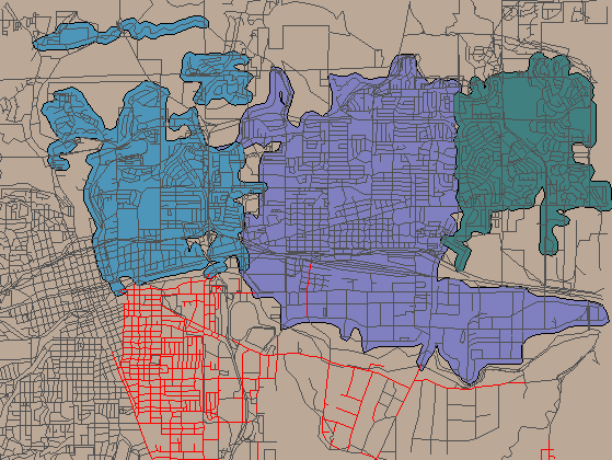
Zip codes are linear features associated with specific roads or with specific addresses such as apartment buildings or military bases that are best regarded as a point. Most often, they do not clump together in groups that may be covered by rational polygons. The map below shows part of Reno, Nevada, (including the main Manifold Net warehouse). This map is fairly typical of the situation in mid-sized urban areas. It is extracted from the US Census Bureau's TIGER/Line 1997 data set, which includes roads as segments of lines, with most line segments coded with Zip and Zip+4 codes for that particular segment. In this note, we will clump both Zip and the Zip+4 extension together under the name "Zip code".
To create polygons from such roads, there are several approaches. One possible approach is to select all line segments with the same Zip code and to then draw an area (polygon) that encloses them. The blue, purple and green areas were created in this way. The lines in red show road lines that were selected because they all have yet another Zip code in common. Immediately there are several pathologies visible in this map.
First, note that the blue area is not contiguous. Second, note that there are many regions of overlap between the blue and the purple areas and between the purple and green areas (we should have used transparent areas so that the regions of overlap were more clear). Third, note that at least one road segment highlighted in red (all having the same Zip code) occurs inside the purple zone where it is completely surrounded by all adjacent streets having a different Zip code.
The above situation is extremely common. In fact, we used this particular map at random because it happened to be a part of the Reno area in which the main Manifold warehouse is located. Any urban map in the US will show similar, if not even more bizarre effects. Rural maps can have such a sparse network of roads with such strange zip code assignments that some rural areas cannot even be approximated with zip code regions.
For the above reasons, any map that purports to show "Zip Code Areas" or "Zip Code Polygons" is not an accurate map. It is at best some sort of approximation and most likely is wildly inaccurate in certain regions. The approximations can be useful, but they should not be confused with the real thing.
The US Postal Service, of course, doesn't make it any easier to deal with such issues by making it easy to get Zip code information. This information is not available for download via Internet and is best obtained from the TIGER/Line CD's issued by (of all agencies!) the Census Bureau.